 I decided to leave the new camera behind. It's about 2 lbs with the lens. But I needed to take a camera for a summit photo, and maybe a few others on the way up. So I took the old Olympus.
I started up the road at 7:19am. One of the reasons I got the new camera is that the Olympus had some reliability problems. Plus I had dropped it several times on the Cedar Creek hike. It's still a little bulky for a pocket, and I had to find a place for it. I ended up putting it inside my outer shirt, right above my belt.
I took a few shots with it, but quickly confirmed that this could be a successful mountain climb, or a photo taking trip. Not both.
 On the road below a couple had passed me in an SUV -- a 4WD which got them to the Lily Pond trailhead saving them 2 miles. I figured they were about 40 minutes ahead of me when I reached the bulletin board at the trailhead and saw it parked there.
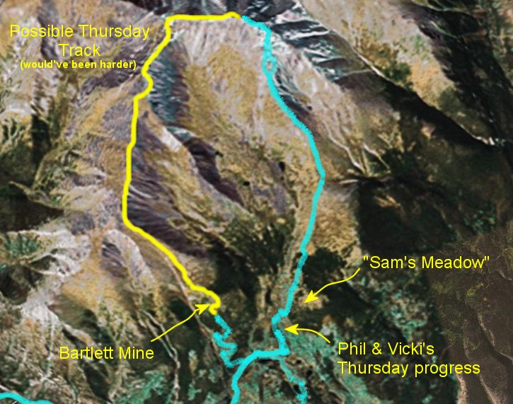
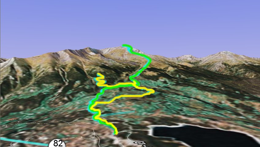
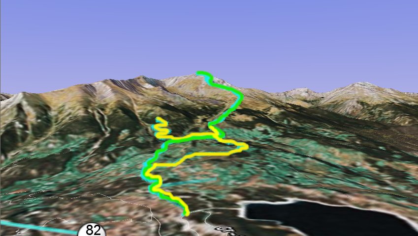
Note: in the first picture above, the yellow path shows our thursday hike, the green path shows the friday path. Click on the picture for a bigger version. Oh... the blue is actual data from my GPS. The second picture shows all the data, plus a yellow path suggesting how we could possibly have reached the top on Thursday. The pictures are from Google Earth.
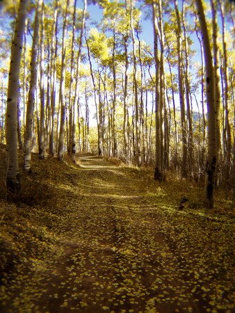
 Within 40 minutes, I reached the wrong turn from the day before. An hour, and I was as far as we'd gotten the day before. About a half an hour later, I reached the meadow Sam had reached the day before. And within 10 more minutes, I could see the treeline.
I was feeling pretty confident. I was also pretty warm, even though it was under 30 degrees when I left. Matter of fact, I had to take my hat off (I let it hang off the back of my neck on top of my pack) because it was getting wet with perspiration.
 When I broke out of the trees at about 11,600 feet, the top still looked pretty far away. In fact, it was probably over two miles away, maybe two and a half or a little more. The climb was fairly relentless. The trail level rarely leveled out for long. I kept running across clumps of trees up to about 12,000 feet where they were stunted, as usual, and then ... tundra.
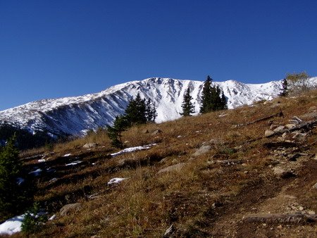
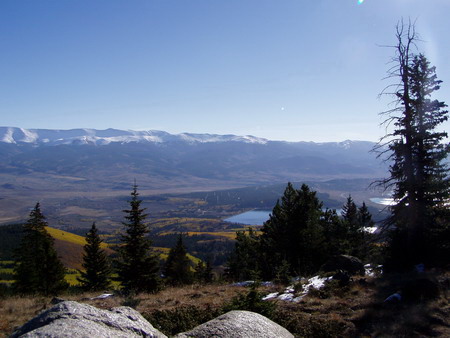
I call this place God's Country. Above the trees. Little lichens and tiny plants that hug the earth for cover and have a growing season measured in a few short summer weeks. I called Vicki at about 12,200 to report my progress. I'd called a couple of other times on the way up as well. It was still pure tundra -- snow was patchy at best. The views were really opening up to the south and east. The mountain still blocked most of the north and the west, but the ridge from Elbert to Parry Peak was snow covered and impressive. Twin Peaks loomed to the south.
 I could now pick out the two people ahead of me on the ridge past the first horn at around 12,500 feet and I pulled out my small binoculars to verify. The were making slow and steady progress. As was I. Emphasis on slow. Between the steepness of the slope and the altitude, I was huffing quite a bit.
There were crickets chirping in the tundra, to my surprise. It was one of the few sounds I could hear. I figured they were little, but I couldn't see any.
 I popped up over the first ridge and got my first look to the north at 12,400 feet, and a strong, cold wind greeted me. My hands got cold from the wind chill and gripping the poles -- which, by the way, I was really beginning to appreciate. My legs were tired. It's easy to make a misstep when you're tired. Twist an ankle on a wrong step. Lots of chances to make a mistake. The poles not only take some of the work away from your legs, but they also help you keep your balance when you start to lose it -- protecting your ankles. It'd be a long hike down with a sprained ankle.
With the cold, I decided to roll my sleeves down and put my hat back on. Matter of fact, I thought I should pull my coat out and put it on as well. But my hands were so cold I couldn't button my sleeves.
 I did bring the John-e Hand Warmer along, so I got it out and filled it with butane. Got my wind-proof lighter out. Couldn't get it to ignite. Low oxygen up here? Butane too cold? Too much wind? I tried warming it up and protecting it from the wind. No flame.
I'd brought my magnesium and flint kit along as well, so I scraped some magnesium on the hand warmer wick, and gave it a few sparks with the knife on the flint. Bam! Flame. I bagged it in the flannel pouch and warmed my hands. Stuck it in my pocket, and buttoned my shirt sleeve. Put on my coat and hat, and headed for that first horn on the rocky, snowy slope to the summit.

The wind died, and I removed the jacket and the hat again. Then I saw someone coming down the mountain. I met him at pretty much excactly 13,000 feet. He had left at 5:30 in the morning. It was his camper down at the lower trailhead this morning. He said he woke up at 3:00 this morning and couldn't sleep. He was too psyched. Heh. I knew all too well what he meant. He asked me where I was from, and I told him. "Ah, a flatlander", he said. He said he was originally from Virginia. When he reached the peak this morning it was 15 degrees and a good 30 MPH wind met him at the top. He said he'd made about 1,000 feet an hour. I reverse calculated and decided that was about what I was doing and used it as an estimate the rest of the way up. He wished me luck.

I ran across a spider in the snow, which I thought was odd. I got my camera out and took a picture. I forgot to re-button my shirt, though, and later the camera fell out. The lens retainer ring popped out. I wondered if the front lens popped out, but somehow I convinced myself that it hadn't. I popped the ring back in, stuffed the camera in my shirt again, buttoned it, and moved on. Hope it is ok.
By now, "beat" was an understatement. I was doing things like counting steps to keep my mind off of it. It helped me pick my feet up. One foot in front of the other. The snow was mid-shin deep in most places, but there were tracks to step in from the people ahead of me, and I used them. The poles were indispensible. I mean -- I PROBABLY could have made it without them, but a lot more slowly, and I wanted to be to the top by 1:00pm -- 2:00 at the latest. I had to get back down. I wanted to be down by 5:00 if I could. Kind of had my heart set on an Elk Steak in Twin Peaks. Plus, you just don't need to be up there late.
The trail kept disappearing and reappearing, in and out of the rocks and snow. I strayed from it when I couldn't find it. Called Vicki from about 13,500 feet. Sam and Vicki were in Leadville, doing coffee shops, the museum, and antique shops. I could see Leadville since I first reached the ridge 1,100 feet down -- I could even make out the colorful brick buildings downtown. It was about 10-12 miles away as the crow flies.
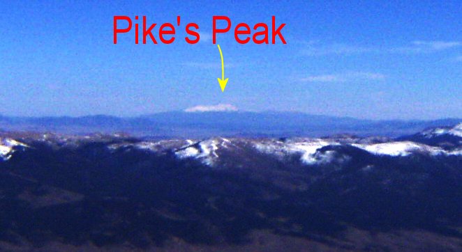
I told them I'd be at the top in about an hour. I tried to take a picture of Pike's Peak from there, but the camera wouldn't turn on. I had that problem last year in RMNP. I hoped it would snap out of it later like it did last year.
Only sheer determination to get to the top kept me going. This was definitely work. However, the views were more than rewarding enough, and they got better by the minute. Only about 500 feet vertical now. I met the couple from the SUV ahead of me on the way down. They assured me it was spectacular. They asked me if I would have taken a ride to the trailhead. I casually said "yes", but it was no big deal ... only a couple of miles. Truth was, especially now, I would have loved it. But I never would have imposed and I didn't begrudge them for not offering -- on top of that, they had no way of knowing that that I planed on going to the peak rather than just hiking around on the trails in the forest below.
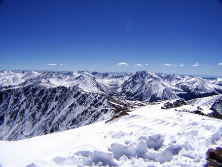
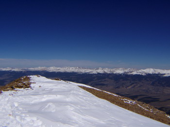 Through perseverence, the peak approached surprisingly quickly. There is a ridge about 6-10 feet wide at the top, maybe 30 feet long, and a pole with some names burned into it. When I hit that ridge, I got my first 360 degree view. It was so stunning, I didn't notice the wind at first.
I had seen Pike's Peak for most of my way up above the tree line about 90 or so miles to the West South West, standing by itself. The Arkansas River Valley and Cripple Creek area in that direction was the only direction you didn't see snow capped peaks to the horizon -- and Pike's Peak sat basically in that window (it was, of course, snow-capped).
I could see Mount of the Holy Cross to the north, and I could even make out the Maroon Bells to the west. I was looking DOWN 1,000 feet on 13,000+ peaks.
 And then that wind finally got my attention. I put on my hat, my gloves, my coat, and my ear clips. I called Sam & Vicki. "I'm at the top", I said. They said "We can see you!"
Huh?
They were at the trailhead parking lot below. They were using my 30x spotting scope from the car. I waved.
"Can you see me waving?"
"No. We can just see what is obviously a person up there. Something flashes white every now and then."
 Is it my phone? I tried flashing the phone at them. No. And I didn't have a signaling mirror. I tried waving my camera -- and while doing that, it turned on. I was relieved. But they couldn't see the camera flashing in the sun, either.
My coat was open, and I was wearning a light tan shirt. It might be catching the sun when I turn to it. That must be it.
They said heat waves coming off the mountain would obscure me at times, but then the wind would blow just right and the air would clear up enough for them to make me out again.
They said they saw someone coming down the trail toward the car. "Ask him if he's originally from Virginia", I requested. He was. The same guy I'd met about 3 hours earlier. They told him I was at the top. He said to tell me he was surprised. He was a kidder.... he also told Vicki all I did was complain about how my lazy wife wouldn't go with me (not true!!!) and that there was a couple up there with two young children and they were doing fine (well, there was a couple, no kids, though).
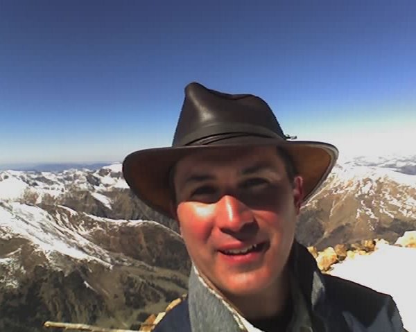
I tried taking some pictures with the camera. I could focus at infinity ok, but nothing close, and nothing zoomed. It was like it was stuck in macro mode. I later figured out that I'd lost the front lens when I dropped it. So I had to use my phone camera at arm's length to take the only picture of me at the top. But I did get a few of the surrounding mountains with the regular one.
I'd planned on eating lunch at the top, but the wind and cold was downright inhospitable. I took some time to look at the views, and called Brian. I could eat down lower where my face wasn't stinging from the wind.
It took me three hours to get down. Again the poles made that possible, on top of saving my knees, they probably saved my neck. The snow had softened in the sun, and I slipped in it easily, especially in my rubbery-legged state.
Vicki and Sam met me near where Sam had dropped me off. They walked up the trail a ways to see me, and I got a big hug and a welcome back kiss from
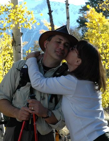 Vicki. She decided I'd be too tired to go out (actually, I kind of wanted to). I was exhausted, but in a good way. I knew I looked it as well. Plus having leftovers saved us a good $60 or $70 anyway.
So, with the help of the Hat of Power, I made it to the top. It was my first official 14er climb. I've been to the top of Evans and Pike's, but drove to the tops of those.
As far as I could tell, I was one of 6 people to make it to the top that day. It felt good. I'm glad I did it.
And yes, I'd do it again.
No comments:
Post a Comment