 The plan was to get up around 6:00 am so we could be on the trail early. Since we didn't have a 4 wheel drive vehicle, an extra two miles each way was added to the climb. The total climb would be almost 6 miles. I had bought an Independence Pass topo map at the forest service office on Wednesday, and I could see the end of Twin Lakes at one edge.
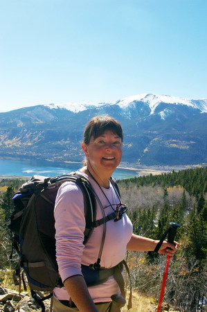
Before we left the cabin, I couldn't find my hat. It wasn't in the car, either. I figured I must have left it down at the creek the evening before. Sam and Vicki had remembered me messing with my hair before we left for the creek yesterday -- wouldn't have done that if I'd been wearing my hat -- but we weren't quite sure. We drove down to the creek, and didn't find it. I miss my hat. That hat and I have spent most of my time in the mountains together. It keeps rain off my head, sun off my face and neck, and out of my eyes. It keeps my head warm when it's cold. Plus, I bought it in San Diego (my birth town) and I'd been looking for just such a hat for a long time. I hope it turns up later. Vicki and I needed to get climbing, and it was already after 8 by this time.
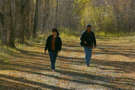
Sam dropped us off a little ways up the 4 wheel drive road -- as far as the Taurus would make it. That was about 0.2 miles. We set off, and Sam went back to the creek one more time to look for my hat. He was going to climb some and take some pictures, but he had no plans to continue to the top.
 We came to a fork in the road, and there was no indication which way to go. The trail didn't appear to be on my GPS, so I looked at my map. I
saw a 4 wheel drive road that split and then came back together after a half mile or so, so I thought it didn't matter. We went up the shorter, steeper fork in the road and ended up in an alpine meadow. The view was awesome of Twin Lakes and the surrounding mountains in the morning sunlight and clear blue sky. We crossed the meadow and the road turned west, just as the map suggested, and we went through some beaver ponds and ended up by a rusted metal sign like the one at Willis Gulch -- but this one was more clear. Mount Elbert, thataway! It wound around another beaver pond, and we came to another fork. There was a large bulletin board with signs over to the left across a bridge, saying "please stay on the trail", etc. I figured the right way to go was over that way, then -- though there was no real indication. I figured the trail would wind back up to the north eventually, even though this way was southwest. And soon we came across one more fork in the road. One that went back down toward the car, the other lead up, and quickly. Again, nothing indicating which way was the right way -- just CTD trail, and arrows pointing ... well, pretty much in all directions. We trudged up the steep one in earnest. After all, we had 5,000 feet to climb.
 It was some of the steepest hiking I've ever done, but it was walkable. It appeared at this point to be another 4 wheel drive road. We wound up several switchbacks, through signs that said "Public Road through Private Property Ahead, Please stay on road" or something to that effect. I knew Lily Pond was on private property, so I figured that must be it.
However, we got up to about 11,500 feet and I hadn't seen the pond yet. Something was wrong. We called Sam. He said he hadn't found the hat, and that he was sitting in a meadow. We thought it must be the one that we'd come across. But after talking to him a bit, I figured out it wasn't. I got the map out, and zoomed out on the GPS.
We were on the wrong trail, headed up a peak to the south of Elbert. We asked Sam if he'd come across a bridge. He had. He said there was a sign pointing the way to Mt. Elbert, and we thought it must be the one we saw. We must've missed something. At any rate, it was 11:30 by now and I knew we wouldn't be making the summit today.

We agreed to go meet Sam wherever he was and headed back down the old mining road. We crossed the bridge, and to our surprise there was a fairly obvious wooden sign pointing to Mt. Elbert ... the opposite direction we'd taken when we'd come to this fork. From the direction we'd come, that sign was behind a large willow bush, and facing the other way. We'd missed it completely (Picture to right: red is the way we came and went, green is the way we should've gone) We went by a few large, smelly beaver ponds which I realized was the Lily Pond area, and through a large aspen grove. Then another sign saying "Mt. Elbert" which pointed to a trail that went up... fast. Sam said he wasn't far up that trail. Vicki was tired. Heck, I was tired. We went up several switchbacks and soon got to snow, which made the trail slippery. Thank God for the hiking poles. These were new to us, but they were proving their worth today.
Still no Sam. Vicki needed to sit down, and sat down on a log right in the snow. We were at about 10,300 at this time. Sam had hiked a little higher. I told him Vick could go no farther, and he started back down toward us. He appeared within about 10 minutes.
 I was bummed. I'd lost my hat, we didn't make it to the top of Elbert. We hiked back down to the car, and I noticed I couldn't focus on anything with my camera. The focus ring had come loose on the lens. Strike three. Bummer of a day, I thought.... knowing that the sights I'd seen were fabulous and I shouldn't be thinking that way.
Back up on the trail a couple of hours before as I was muttering about losing my hat, Vicki mentioned that Sam and I had gotten out of the car at Twin lakes the day before near the Elbert Trailhead parking area. It was then I remembered that I had taken my hat off -- even moved it when I moved once, but still had it laying on the ground -- so I could get down low and look through the camera viewfinder. I'd even told Sam (not that I thought it was his responsibility) "don't let me forget my hat."
Well, I remembered -- that's what must've happened. I had it at the Maroon Bells, I had it in Independence, I didn't have it at the cabin or the creek. That had to be it. It had been left on the side of 82 by Twin Lakes, and there was a decent chance someone had seen it and picked it up.
But there was a decent chance also, it being the middle of the week and less than 12 hours of daylight ... that it MIGHT still be there. We drove up to that spot. And there it was, right where I'd left it. Sam said it was a real mountain hat now, having survived a night alone on a mountain road. It's been through a lot more than that in the mountains, but I agreed, just thrilled to have it back.
I told Vicki and Sam the reason we didn't make it to the top of Elbert was ... I didn't have "The Hat of Power". I put it on. I felt a little better.
 When we got back to the cabin, I tried focusing the camera on various things to see if I could get the focus ring back on right. But no matter what I did, manual or automatic, it wouldn't focus on anything. Now that's just odd, I thought. At about that point, I started looking for other things, and I noticed there is an eyepiece focus adjustment on the camera. I put it in the middle, and tried focusing again. Bingo!
There was nothing wrong with the lens after all, the eyepiece focus compensation was just out of whack. I figured out which way the focus ring went on -- and we set off for Vicksburg, a few miles south and west of us. Two strikes of my three strike day had been revoked. I was feeling better. But I could feel Mt. Elbert scoffing at me.
It was getting late in the afternoon, and we were driving west into the valley where Vicksburg lay. The sun was shining through the aspen leaves, and we were pretty much gasping at the views on every turn. Sam and I got out to shoot a lot of pictures (still need that oversized lens
hood!!!). Missouri Mountain was in this valley as well, and I was trying to figure out which one it was. We saw trailhead parking for Missouri Gulch, and across the road was parking for Vicksburg Museum. We saw a couple of
 cabins, but figured that couldn't be the "Ghost Town" we were looking for. A gate was closed, and it said "Private Property". So we pulled in to the trailhead parking to see if there was any Vicksburg information there. It had to be close, according to the map. There were a couple of guys, one from the Oklahoma University Health Sciences Center (and I think maybe his son?) camped out there, about to make a two day assault on three 14ers, including Missouri Mt., Mt. Belford, and Mt. Oxford. I was jealous ... and interally shamed at my failed attempt today on Elbert -- all in all probably an easier climb (though I guess I don't know that for sure, but that's what I thought!) Talked with them a while, and they said they had the same problem at Elbert before -- it was poorly marked. They went up the same peak we had started up (only they went all the way to the top of it at least) So I felt a little better.
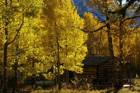 They encouraged me to try again, and I told them I was thinking about it but frankly I was beat from today's feeble attempt and I knew Vicki wasn't up for it. She encouraged me to try as well, though. A solo attempt. Hmmmmmm. Maybe. We went back to the place that said "Vicksburg Museum Parking" and a couple was emerging from the area -- that was indeed it, you just had to go back a ways to see the other cabins.
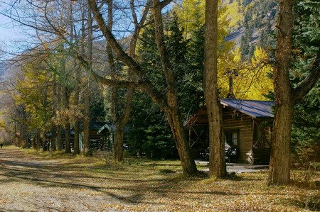
They were boarded up for the winter. As a matter of fact, it's not acutally a ghost town at all. The cabins are owned, and lived in during the summer - mostly by decendents of the original owners. Some you can rent out. There was a little of the self-guided tour the forest service office lady had mentioned. We read some of the signs and listened to a recording. Took some pictures, and went back home for a spaghetti dinner.
No comments:
Post a Comment