 Tuesday we decided to try something a little closer to home -- a hike up around Lake Creek, the one that dumps into Twin Lakes up by Twin Lakes. We went in to Granite first for gas and some sunscreen. We got burned from the wind and sun at Maroon Bells the day before, and the snow didn't help. The store
  owner was a bit grumpy -- Vicki tried to engage him in conversation. Maybe it was a bit early in the morning. We got our gas & sunscreen and left. Stopped at the Twin Lakes store and met a lovely mountain girl (woman -- she was a grandmother) tending the store. She gave us all kinds of advice -- from climbing Elbert, when to start, who died and why, etc. She had a nice dog named Cassidy as well. We asked her about the Willis Gulch trailhead, and she said it was about a mile and a half down the road.
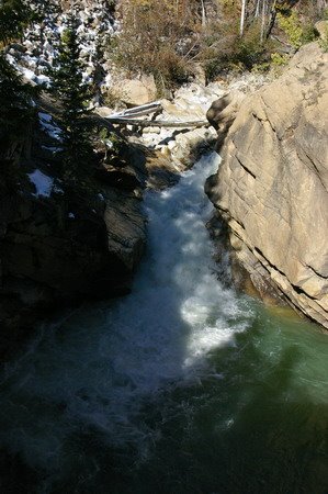 The place across the street advertised "The Best Coffee in Colorado" -- and Sam went over to fill his cup -- but they were out and apparently the Coffee Man was out doing chores. Too late in the morning, I guess. We drove down to the trailhead and tried to guess which trail was which. We ended up in a campsite next to 82 -- pretty trees, and a small gorge with water raging through it. But it wasn't the Willis Gulch trail. We headed back, and passed something that looked sort of like a trailhead, but it didn't say which trail. It was a rusted metal sign with stenciled letters cut out of it.
We went back and compared the topo map with the GPS and I insisted that Willis Gulch was on the other side of the ridge sloping off of Twin Peaks to the east. Sam decided that meant the rusted sign was the trailhead, and we traipsed off down the trail. It wasn't long before the trail split -- one said "Twin Lakes Trail" continuing to the East, the other said "Little Willis". Not excactly clear. We picked "Little Willis", and started climbing steeply up the slope of the ridge.

The way the trail looked on the topo map, we thought it should stay along the bottom of the ridge and turn up the gulch later. I decided we were on the wrong trail, climbing some peak called "Little Willis" (turns out I was wrong, we were on the Willis Gulch trail -- but it worked out). We followed the Twin Lakes trail 150 yards or so more and ran across a group of three women we had met by the car. They were having a picnic and wine by some boulders. I took some shots of aspen in the mouth of Willis Gulch, and Vicki and Sam hiked on in
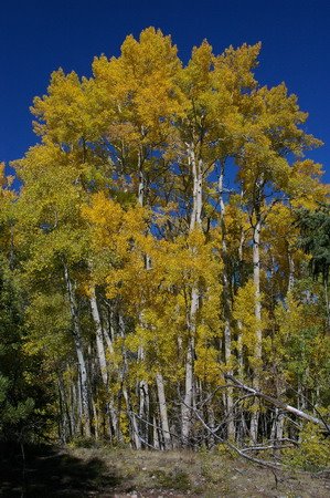 the meantime. Suddenly I heard Vicki say "Oh my Good Lord in Heaven, Phil!" -- which I took to mean "Wow!" Which was the correct interpretation. Because the next 1/4 mile of trail had some of the best aspen scenery we'd see all week. There was a grove of tall, bright yellow ones against the clear blue sky. Got several shots of that, and we hiked on through an incredibly large grove of aspens dropping leaves like gold flakes onto the trail, carpeting it like something out of Rivendell in Lord of the Rings. A few symetrical spruce and some colored underbrush punctuated the forest, and we were literally in awe.
Sam got ahead of us, and Vicki and I caught up to him sitting by the stream coming out of Willis Gulch toward Lake Creek. We had a snack, and decided to head back to the car. I wanted to visit the Forest Service office in Leadville to find out about conditions on Elbert and get an updated forecast for the week, and they probably closed at 5:00. Sam and I decided it would be faster to follow the trail through the marsh on the western edge of Willis Gulch back to 82 and hike back to the car. (Later I figured out it would have been much shorter to go back the way we came... but ... well, read on).
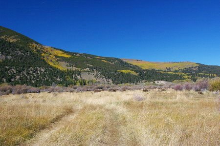 We hiked out of the woods to a field at the edge of the marsh. It was obviously a fairly often used ATV trail at this point, and dried grasses stretched between the woods, another large aspen grove, and willow shrubs in the marsh stretching to the lake off to the east. After hiking through some willows, we came upon Lake Creek -- a braided stream through gravel bars at this point on the homestretch to the lake. We looked for a place to cross.
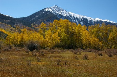
To our surprise, there was quite a bit of water rushing through the creek even on this flat-ish land, and there were no obvious places one could rock-hop across. The best place I found I could see was about knee deep at the worst, but the current was pretty strong there. Sam went downstream and found a place where the braids multiplied, offering a way across several of them, but the final channel was about waist deep -- way too deep for this current. So we went back to the spot I found.
 I sensed Sam and Vicki were skeptical, so I just took off my shoes, rolled up my pants, and proceeded across with my hiking poles for balance and bracing against the current. I was across pretty quickly, and my Bass Pro Teflon pants, though they unrolled a bit into the water, did their thing and didn't get soaked. They would dry quickly.
My trek convinced Sam & Vicki it was a viable trip, so they followed suit. I thought about Vicki's diminished balance since her acoustic neuroma surgery and decided to go back across and carry her pack and stand behind her downstream on her way across -- both for encouragement and to help her keep her balance. Don't want any bad experiences keeping her from wanting to hike around in the mountains!!!! ;-)
This being my third crossing of the stream, and the stream being snowmelt, my legs were numb from my calves to my feet, but I knew it was only a minute or two and I'd be fine. We all got across. I sat down to put my shoes and socks back on. And I noticed.... blood... on the rocks... by my shoes. Who cut themselves? I didn't feel anything, couldn't have been me. I looked around. Then I checked my right foot. There was a sizable chunk of skin missing from the ball of my right foot. It wasn't bleeding much, but that's where it was coming from. I didn't feel anything, and it wasn't bleeding much -- because of the cold water. Apparently I cut it on a rock on one of the crossings. Patched it up with the first aid kit, put my socks and boots back on, and we trekked off through the willow bog.
 Unfortunately, the trail had sort of vanished. We continued on what was probably a deer trail. We could see the town of Twin Lakes and the road, it wasn't like we were going to get lost. We made a bee line for the road.
The trail crossed several more less palletable small streams with lots of rotting vegetation -- you could smell the beaver musk and rot. But at this point, this was the best way to go. We knew we were crossing a bog when we started and we might run in to stuff like this, but had been over-sold by the dry start on the south side of it.
We emerged at the road, and by the mile marker I figured we had a little more than a mile hike down the shoulder of 82 to the car. Sam got a phone call and slowed down, and Vicki and I kept hoofing toward the car.
A woman pulled up in a car and got out, saying she was shooting for a website on Colorado... things to do... and wanted to know if she could shoot me hiking down the road. Guess it was the hat and the World Wide Sportsman garb from Bass Pro. She shot some pictures and took off. We made it to the car at about 4:00, circled back, picked up Sam, and tore out toward Leadville and the Forest Service office. Half an hour later that I'd planned, but all in all, I was optimistic, as Leadville is about a 25 minute drive away from here.
 This wasn't a big office like the one in Idaho Springs, but I did end up talking to the young lady behind the counter. The forecast was now for a cold front to come through tomorrow (it was 70 degrees that day in Leadville) -- with a few clouds and little chance of precipitation. Thursday and Friday looked sunny.
She also said that over the weekend there were reports of knee-deep snow above the treeline on Elbert. Hiking it might be difficult. At any rate, I decided an Elbert try would have to wait until Thursday or Friday, leaving tomorrow open.
We asked where to get a good burger and beer, and they recomended Rosie's Brew Pub -- the highest brew pub in the country (everything's "the highest" in Leadville - the town is at 10,200 feet).
Rosie's was good, indeed. We stopped at a drug store on the way out for some big bandaids for Vicki's blisters... plus she wanted some chocolate.
Got those, and went home.
I wanted to go up above the treeline again the next day, and that meant going over the pass. Maybe find Independence, a ghost town on the Aspen side of the pass. Sam said as long as we were going that far, we might go back to the Maroon Bells. Our pass was good for 5 days.
Twist my arm.
It turned out that the color balance on Sam's camera that day was set for tungsten, so most of his pictures turned out blue. He wanted another shot at them.
To bed again.
(the following picture isn't for the trip. It's just so I can use blogger's "free web hosting" for my profile picture. This is from the Aug 2007 trip. I just needed someplace to stash it.)

This is a great trip report. I'm making a list of hikes in the Twin Lakes area and I've linked to this page! :)
ReplyDelete