 Well, the big walkabout happened this past weekend, in which Ryan and I hiked from Pine Ridge near Ashland up to Rutherford Bridge ... near Englewood. All in all around an 8 mile hike through Mark Twain National Forest on the Cedar Creek Trail System. I'll warn you in advance that I did not take a ton of pictures on this trip due to some of the difficulties we encountered. Next time we try this it will be a lot more relaxed.
We'd planned on doing this for some time, and waited for the first
 break in the hot weather combined with a weekend we were both free. That happened last weekend. Before that, we experimented with various soda can alcohol stove designs and our lightweight mess kits.
I had borrowed an external frame backpack from Mark (actually, technically it is an internal frame pack, but the frame elements are, in fact, on the outside of the pack) that appears to be U.S. Army issue, or at least was at one time as verified by Brian -- who knows about military product codes (having been in Supply Administration for the U.S. Marines). The pack itself isn't all that light. I didn't weigh it by itself (I should do that tonight) but I imagine it weighs 7 lbs or so. I put my 3 lb, 2 oz tent and my fleece sleeping bag (about the same weight?) in it, and strapped my ... ~5 lb self-inflating mattress pad to it. That gets us up to ~18.5 lbs. Add 4 lbs of water, a 1 lb water filter, 0.5 lb cook kit, 1 lb of fuel.... 21 lbs. 2 lbs of food. another 4 lbs of clothes.... you see where this is headed. I weighed it the night before we went. 29 lbs. That's about the upper limit of "lightweight" for this kind of trip.
Before I left we added a few more things. Little did I know I was carrying about 39 lbs.
The backpack frame is ultimately too small for my torso. I can't get it to transfer the weight to my hips. It wants to tug on my shoulders too much. Finally, I cinched it down on my hip bones so tight that they hurt slightly, and I could get most of it to transfer. It isn't a wide-belt one like my Mountainsmith Daypack. I started to feel for our soldiers.
We dropped Ryan's car off at Rutherford Bridge, and Vicki took us to Pine Ridge. We went to the
 parking area supposedly by the trailhead, and spent the next hour ... trying to find the trailhead. It turns out that parking place really isn't for the trailhead. Frankly, I'm not sure what it's for. We used the GPS to head toward where we were sure the trail should be. Ended up crossing a road... turns out the first part of the trail was along this road. We'd gone too far, so we had to backtrack to see where the trail split off of it. We found it, and headed out on our way.
That first hour we spent in a field with tall grass. I had made a mixture of sulfur and baby powder to keep chiggers at bay, and we'd put it on our socks and legs. Next time, we'll have to be more liberal with it.
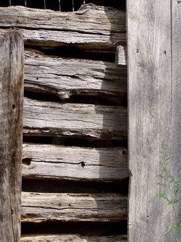
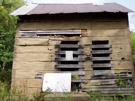 We hiked through a pretty field further down the trail, and wound our way to the Nevins Homestead -- a cabin and a barn, both falling apart, where a black family had lived years ago from 1905-1982. The original cabin may have been built as early as 1856. There was a little history written up on a sign next to the house. Columbus Nevins was active in the Civil Rights movement.
From there we crossed CR363 and into the next section of trail.
We stopped for lunch around 1:30 ... about 2 and a half hours into the hike. We had used half our
 water. There wasn't any water in any of the dry branches of the creek system to be had. At that point I knew we pretty much needed to camp by Cedar Creek, which meant going all the way to "the hotdog spot". And we weren't even halfway there. We had passed a group of ladies walking the trail, and I figured they must be staying around a campsite we knew we should be coming upon any time. They came back and passed us while we were eating lunch and resting, so I asked one of them if that's where they came from, if it was close, and if there was any water. Thankfully, they said it was about 3 minutes ahead and yes, it had water.
So we tanked the rest of our water and struck out for the campsite. Filled our hydration bladders and an empty water bottle I had brought along just in case.
The next leg of the journey was around a mile along a gravel county road, and we picked up the pace. Caught a few minutes of the MU football game on a little radio Ryan had brought. We were ahead 20-7 with something like 9 minutes left. But we lost reception. That did, however, help pass the time on this not-so-interesting part of the journey.
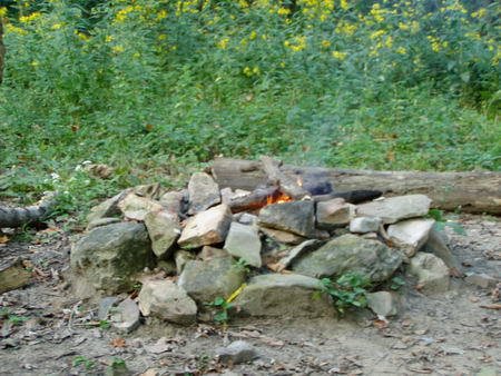 Eventually we hit another trailhead where the trail went off the road and up toward the trail loop that leads, in part, to "the hotdog spot" (so named because that's an established camp site with a fire ring Ryan and Daryl ... and I ... have often stopped and cooked a lunch of hotdogs over a fire.
All in all, it's a generally hilly hike, but nothing too steep. We went through one large field early on, and a smaller one on this leg. At one point a trail ride of about 30 horses came down the trail, and we stopped and let them pass with appropriate "howdy"'s and small talk with the riders as they passed. And before we knew it, we were at the junction with the other trail.
This whole time I had been constantly adjusting my backpack, trying to keep my shoulders from cramping up without cutting off the circulation to my legs. I'd finally found a pretty good compromise, though.
We sat on our little tripod folding seats we packed along -- and decided they were worth their two pounds of weight. The hotdog spot shouldn't be more than 25 minutes away to the West.
We struck out for it after about 15 minutes. We considered camping on Gilligan's Island (our name for it) where our winter/spring walkabouts usually ended up since we more likely wouldn't have company there, but that would be another 30 minutes of hiking, plus 30 more in the morning. We sat down.
When we stood up, we both realized how beat we were. I was dizzy. Low blood sugar. It was about 4:00 when we got there. We set our tents up. I thought a nap sounded really good. But I probably wouldn't have gotten up. I laid down on my self-inflating mattress for a few minutes and forced myself to get up.
We cooked dinner -- Dried instant rice/bean meals to which I added texturized vegetable protein (tastes like chic-ken ... well, sort of). Started to get a second wind. We played around with the three survival kits Ryan had brought to test out. Started a fire with a flint & some oil soaked cotton balls that were in one. Sat on our chairs. Drank Turkey out of our flasks. Enjoyed a pipe, the fire, and the sounds of the Mid-Missouri forest. We even got a whipoorwill right around dark. And then we crashed.
Got up at about 6:30 the next morning. Filtered some water from the creek to cook our oatmeal breakfasts, then broke camp and hiked out. I got phone reception from the top of a bluff and called Vicki to let her know we were on our way out.
We're still pretty sore, and Ryan got downright infested with chiggers. I got a few down by my ankles and a couple under my watch.
We'll do it again sometime, with a different backpack, less weight, cooler weather and after the chiggers get killed off by frost -- or we'll go nuts with the sulfur powder. The only place Ryan didn't get chigger bites on his legs was where he'd spilled a bunch of it on his leg.
And that's the name of that story.
No comments:
Post a Comment